How to read the Saltwater River
Some people may think that using an inflatable packraft to paddle on Puget Sound is crazy. It is true that there are plenty of other watercraft better suited for the environment. It’s a little bit analogous to riding a fat-bike on pavement. It gets the job done, but not nearly as efficiently as a carbon road bike. With a little planning, the packraft can be a very good tool to ride the saltwater river especially when you factor in the appeal of packing your boat prior to and after the trip and strapping it on your bike. Today’s blog will focus on how to read this “saltwater river” and plan a trip. It’s also possible to get out the packraft and paddle many other spots on Puget Sound treating it like a flat-water paddle. I have done these many times, but paddling with the tidal current is generally a bit more enjoyable.
Pick your Route: Visit the Route Finder to find a suggested trip. Just for example demonstration here we will pick the Washington Narrows in Bremerton.
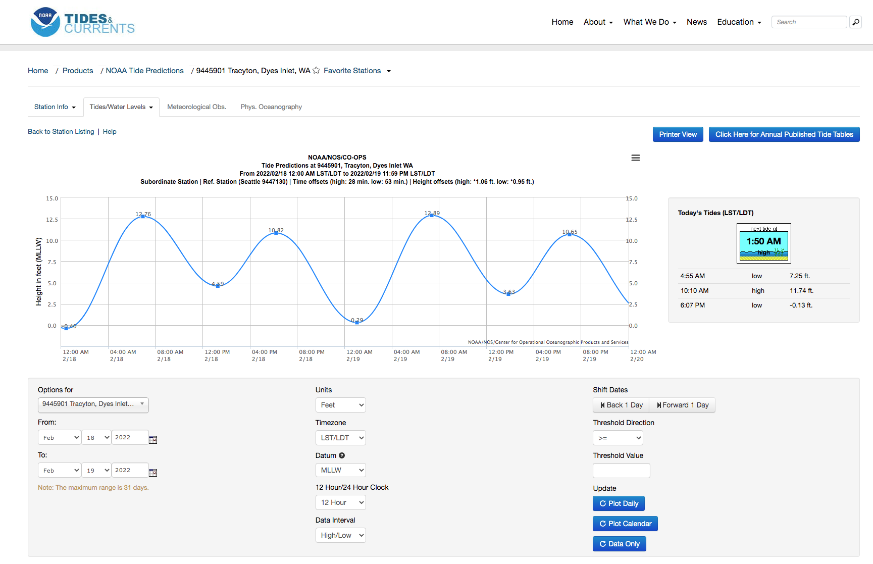
Check the Tides: Visit the NOAA tide table page for the route that you have selected (see water flow link on specific Puget Sound route page). The default view will look like this:
Note: Puget Sound fills from the Strait of Juan de Fuca between Vancouver Island and the Olympic Peninsula. Tide predictions will vary depending on location within Puget Sound. In general, High tides will arrive sooner in Northern Puget Sound than southern. The specific tide table link on the routes page will take you to the tide table page in nearest proximity to the selected route.
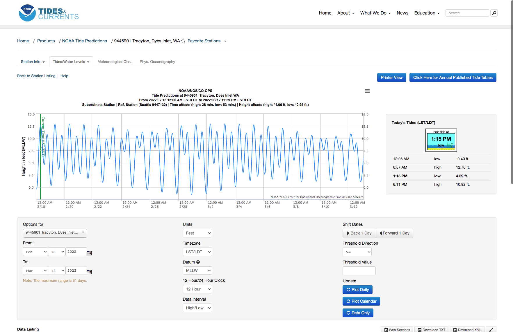
Expand the Date Range: The next step is to expand the date range. I generally like to plot about one month of tides. To expand the range select a new ending date further in the future in the lower left of the website. Once the date is picked, update the plot by clicking the “Plot Daily” button in the lower right. The new tide table may look like the following:
Scan the Chart: The next step is to scan the chart for the largest tidal changes (i.e. find the lowest Lows and the Highest Highs). You can move the cursor over the chart to display values and time of day (TOD). Looking at the example above, there are some large swings near 2/27-3/03. If these dates fit your schedule then continue to the next steps. If the dates do not work, then continue to scan the next month for agreeable dates.
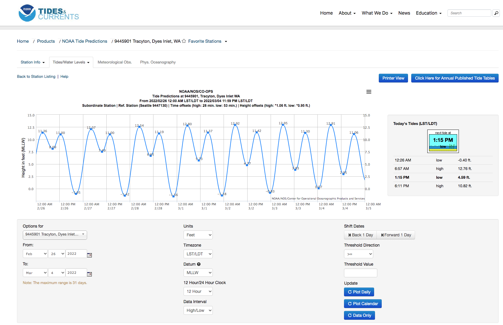
Zoom into selected Dates: The next step is to zoom into the selected date range by typing the specific date range into the lower left of the website and clicking “Plot Daily” after. The example should look like this:
Narrow Down the Trip: In the example above the two best dates for maximum tidal current would be the flood tides early in the morning of 03/01 and 03/02. Feb 28 has a -1.56 low tide at 10:11pm flooding to a 12.80 high tide at 5:17am on March 1st. There is one big problem here though and that is that this flood occurs at night, so it will not be an ideal time to plan a bikeraft trip. So what next? It’s very often that the maximum tidal swing will not work out for one reason or another. Maybe the date doesn’t fit your schedule? Maybe the weather is really bad and there is too much wind? Maybe it occurs at night, like this example. The next step is to try and find another solution. In the chart above there are pretty good ebb tides preceding these flood tides. Let’s look at the ebb tide on 02/28. The high is 11.19 at 2:48pm and it’s ebbing to the -1.56 at 10:11pm. In general a good rule of thumb is to plan on being on the water around 3hrs after (+/- 1hr) the preceding tide max/min. So even for this date, it’s not ideal as you would be bumping up against running out of daylight. Finally, let’s look at the previous date Feb 27. The high tide of 11.00 occurs about one hour earlier at 1:40pm. This could be a possible trip date planning to get on the water a couple hours after the high tide.
Check the weather: The next step is to check the weather forecast. For Puget Sound trips the wind can easily cancel your trip. Check the wind forecast. It’s important to check the wind speed as well as direction. Learn and understand principles of wind direction and fetch and their effect on waves. Packrafts do not easily paddle into headwind so it’s extremely important to know the forecast beforehand.
Plan your Logistics: If everything looks to be a go then plan your logistics of the bikeraft trip. Are you riding an Ebb tide or a Flood? This will determine your direction of paddle. Do you want to paddle first and bike after? You will need to pre-stage and lock your bike at the take-out. Are you going to bike first and then paddle? You will pick up your bike after the trip. See Lock-n-Paddle/Paddle-n-Unlock
Reading Tidal Water: Finally a note about reading tidal water. In general all of the principles of reading river flows still apply, but on a larger scale. In particular there are some key things to remember:
Narrow waterways increase the tidal current. The routes page seeks out narrow passages in Puget Sound to take advantage of this.
Points of land will create eddies. This is just like on a river but at a larger scale. Sometimes the current near the shoreline will be going against you if there is an eddy. Look at the map and try to identify potential eddy flows formed by points of land.
Get out there and enjoy the “saltwater river”. If you enjoy this site and want to contribute please consider a donation.


